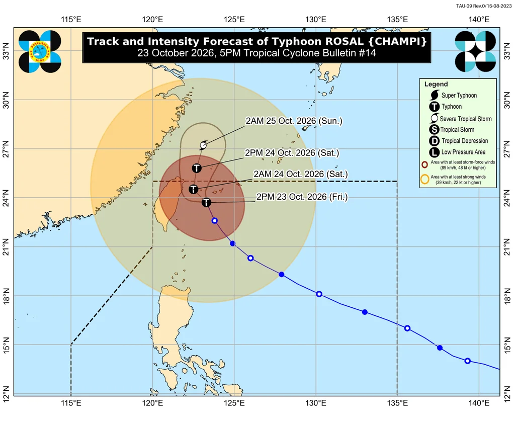
Typhoon Rosal is moving away from Batanes, easing the prospect of significant rain there while leaving parts of Northern Luzon and other regions exposed to showers, strong gusts and hazardous seas. The storm was 385 kilometers north northeast of Itbayat at 4 pm Friday, October 23, moving north northwest at 20 km/h.
The Philippines’ weather bureau, PAGASA, expected Rosal to leave the Philippine Area of Responsibility on Saturday morning, October 24. Its sustained winds had reached 155 km/h, with gusts up to 190 km/h. Rosal had peaked as a super typhoon, with sustained winds of 215 km/h.
Rain and wind risks continue
Rosal’s outer rainbands and the trough extending from the storm could bring scattered rain and thunderstorms over the next 24 hours. The forecast areas included Batanes, Cagayan, Isabela, Ilocos Norte and Ilocos Sur, as well as La Union, the Cordillera Administrative Region, Palawan, Masbate and the Visayas. Parts of Mindanao and nearby islands—including the Zamboanga Peninsula, Misamis Occidental, Camiguin, Surigao del Norte, Dinagat Islands, Basilan and Tawi-Tawi—were also in the outlook.
As of 5 pm Friday, PAGASA had kept tropical cyclone wind signals in place across parts of Northern Luzon:
Signal No. 2
Gale-force winds of 62 to 88 km/h; minor to moderate threat to life and property
- Batanes
Signal No. 1
Strong winds of 39 to 61 km/h; minimal to minor threat to life and property
- Northern Cagayan: Santa Ana, Gonzaga, Lal-lo, Santa Teresita, Camalaniugan, Aparri, Buguey, Gattaran, Baggao, Santa Praxedes, Claveria, Sanchez-Mira, Pamplona, Ballesteros, Abulug, Allacapan and Lasam, including the Babuyan Islands
- Northern Ilocos Norte: Pagudpud, Adams, Bangui, Vintar, Burgos, Bacarra, Pasuquin, Carasi and Dumalneg
- Northern Apayao: Calanasan, Luna, Santa Marcela, Flora and Pudtol
Strong to gale-force gusts from Rosal’s periphery were forecast across most of Luzon and the Visayas, along with the Zamboanga Peninsula, Misamis Occidental, Basilan, Tawi-Tawi, Davao Occidental and Davao Oriental on Friday. On Saturday, gusts could affect Batanes, the Babuyan Islands, Ilocos Norte, Aurora, northern Quezon, the Polillo Islands, Bicol, Romblon, Capiz, Iloilo and Negros Occidental. Batanes and the Babuyan Islands remained in the forecast for Sunday.
Seas remain dangerous in the north
Marine conditions were beginning to improve, but PAGASA still warned that travel could be dangerous, particularly in the northernmost provinces. Waves along Batanes’ northern coast could reach 7 meters, with up to 6 meters along its other coasts. The Babuyan Islands could see waves as high as 5.5 meters.
Waves could reach 5 meters off Ilocos Norte and northern mainland Cagayan, and 4.5 meters off Isabela, northern Ilocos Sur and the rest of mainland Cagayan. Small vessels were advised to stay out of areas with rough seas, where waves could reach 4 meters along parts of La Union, Aurora, Pangasinan, Ilocos Sur, Catanduanes and Samar. Seas of up to 3.5 meters were forecast in parts of Bicol, Samar and the Polillo Islands; other listed coasts faced waves up to 3 meters.
Moderate to rough seas were expected off Surigao del Sur, parts of Bataan and Lubang, and other stretches of La Union and Pangasinan, with waves up to 2.5 meters. Waves could reach 2 meters along parts of Batangas, Cavite, Occidental Mindoro, Palawan, Davao Oriental, Lubang and the Kalayaan Islands. Small vessels in those areas were advised to take precautions or avoid sailing if possible.
Rosal’s exit and the seasonal shift
After leaving the Philippine Area of Responsibility, Rosal could weaken into a severe tropical storm by Sunday morning, October 25. It entered the area on Tuesday, October 20, as the Philippines’ 18th tropical cyclone of 2026 and the first for October. PAGASA had earlier estimated one or two cyclones could form or pass through the country during the month.
The country is also shifting from the southwest monsoon, or habagat, which ended on October 5, toward the northeast monsoon, or amihan. The coming monsoon period could bring warmer conditions than usual: a strong El Niño in the tropical Pacific was forecast to become very strong in the fourth quarter of 2026.