MANILA, Philippines – The Philippine weather bureau issued a warning on August 2 that Tropical Depression Luis is set to deliver considerable rainfall over the next few days, affecting multiple regions.
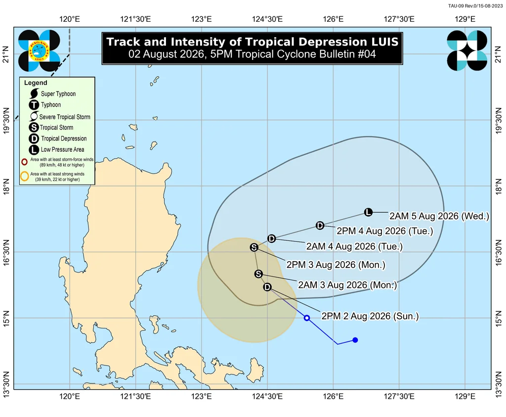
As of 4 PM on Sunday, Luis was located approximately 285 kilometers east of Baler, Aurora, and was tracking northwest at a speed of 15 kilometers per hour. The storm recorded maximum sustained winds of 55 km/h and gusts reaching up to 70 km/h.
Track and Forecast
Per the latest briefing by the Philippine Atmospheric, Geophysical, and Astronomical Services Administration (PAGASA), Luis is likely to remain over the Philippine Sea. However, it poses a risk of nearing or making landfall in Northern or Central Luzon if it shifts westward. There's potential for Luis to intensify into a tropical storm, with forecasts suggesting it may weaken back to a tropical depression by August 4 and dissipate into a remnant low by August 5.
Rainfall Projections
PAGASA has outlined potential rainfall impacts for the upcoming 48 hours:
From Sunday afternoon, August 2, to Monday afternoon, August 3:
- Moderate to heavy rain (50-100 millimeters): Pangasinan, Cagayan, Isabela, Quirino, Zambales, Tarlac, Nueva Ecija, Bulacan, Aurora, Quezon.
From Monday afternoon, August 3, to Tuesday afternoon, August 4:
- Moderate to heavy rain (50-100 mm): La Union, Pangasinan, Benguet, Isabela, Quirino, Aurora, Nueva Ecija, Bulacan, Tarlac, Pampanga, Zambales, Bataan, Metro Manila, Cavite, Batangas, Rizal.
Apart from these areas, Luis is expected to cause widespread rainfall across the Ilocos Region, the entirety of Cagayan Valley, Central Luzon, Calabarzon, Metro Manila, Bicol, the Cordillera Administrative Region, Occidental Mindoro, Oriental Mindoro, Marinduque, Romblon, and Western Visayas. Thunderstorms and scattered rain will likely persist into the evening.
Impact of the Southwest Monsoon
Furthermore, the southwest monsoon, or habagat, will contribute additional rain throughout the week, particularly enhanced by another tropical system, identified internationally as Typhoon Dolphin, which is currently positioned outside the Philippine Area of Responsibility (PAR). The rainfall outlook pertaining to the southwest monsoon is as follows:
From Monday afternoon, August 3, to Tuesday afternoon, August 4:
- Moderate to heavy rain (50-100 mm): Occidental Mindoro.
From Tuesday afternoon, August 4, to Wednesday afternoon, August 5:
- Heavy to intense rain (100-200 mm): Zambales, Bataan, Occidental Mindoro.
- Moderate to heavy rain (50-100 mm): La Union, Pangasinan, Benguet, Tarlac, Pampanga, Bulacan, Metro Manila, Cavite, Rizal, Batangas, Antique.
Current Storm Status and Future Developments
As of now, fewer regions find themselves under the current Signal No. 1 due to winds largely remaining offshore:
- Polillo Islands
- Camarines Norte
- northern regions of Camarines Sur (including Caramoan, Garchitorena, Lagonoy, Tinambac, Siruma)
- northern stretches of Catanduanes (covering Pandan, Caramoran, Bagamanoc, Panganiban, Viga)
Moreover, PAGASA does not discount the possibility of escalating to Signal No. 2 if Luis strengthens into a tropical storm.
The influence of the southwest monsoon and the outer bands of Luis are forecasted to produce strong to gale-force winds in various areas:
On Sunday, August 2:
- Marinduque, Occidental Mindoro, Oriental Mindoro, Romblon, Masbate, Sorsogon, Caluya Islands, Northern Samar, Samar, Biliran, Siquijor, Southern Leyte, Camiguin, Dinagat Islands.
On Monday, August 3, and Tuesday, August 4:
- Most of Luzon, much of Visayas, Lanao del Norte, Misamis Occidental, Camiguin, Surigao del Norte, Dinagat Islands, Sarangani, Davao Occidental, Davao Oriental.
Within the next 24 hours, expect moderate-to-rough sea conditions in several seaboards:
- Eastern seaboard of Davao Oriental – waves reaching heights of up to 2.5 meters.
- Seaboards of Isabela, Surigao del Sur, and Davao Occidental; along with eastern seaboards of Cagayan, Catanduanes, and Northern Samar; northern seaboards of Aurora, Camarines Norte, Camarines Sur, and Catanduanes; and the remaining seaboard of Davao Oriental – waves could peak at 2 meters.
Mariners should exercise caution or, if possible, refrain from sailing during this period.
After transitioning into a remnant low by Wednesday, Luis is expected to be absorbed into the circulation of Typhoon Dolphin, which was located about 3,100 kilometers east of extreme Northern Luzon as of 4 PM, still moving west-northwest at 25 km/h. Dolphin maintains maximum sustained winds of 175 km/h, with gusts up to 215 km/h.
PAGASA Weather Specialist Grace Castañeda-Carpio mentioned that while Typhoon Dolphin is currently deemed "less likely" to enter PAR, its influence on the southwest monsoon is virtually guaranteed. Luis, marking the Philippines' twelfth tropical cyclone for the year, is the first recorded in August. The meteorological agency had previously stated that between two to four tropical cyclones may develop within or approach PAR this month.
– Rappler.com